



About US Topographic Map
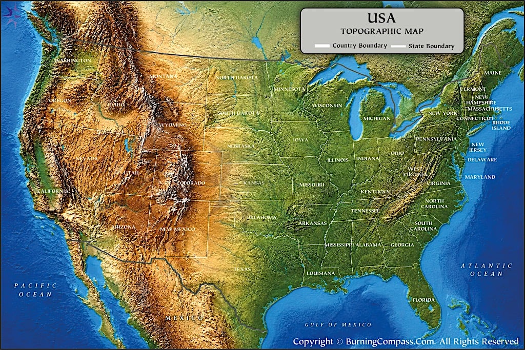
The US topographic map displays the physical features and terrain of the United States in great detail. The major mountain ranges are depicted as well as the corresponding valleys, plains, and plateaus in between. The state boundaries are also illustrated and labeled. The major bodies of water, including the Great Lakes, the Gulf of Mexico, the Atlantic Ocean, and the Pacific Ocean, are highlighted as well. The USA topographic map uses shaded relief to illustrate the varying elevations and terrain types found throughout the United States.
Topography of the United States
The geography of the United States is diverse. The coast and interior of the U.S. are mostly broad, shallow coastal plains and low interior regions. In the West, there are high mountain systems, plateaus, desert basins, and deep canyons. The geography of the U.S. can be divided into several physical regions. The physical regions are determined by differences in elevation, geology, climate, amount and type of erosion, and tectonic activity. For the contiguous United States, the U.S. Geological Survey (USGS) has outlined the major physiographic divisions and individual provinces. The physical regions are described in terms of their topography, geology, geologic structure, and geomorphic history.
A look at a topographic map of the United States will reveal the basic characteristics of the Western States, which are generally more rugged and of greater elevation than the central and Eastern States. These states are comprised of many large mountain ranges, some high plateaus, a number of low to flat basins, and arid desert regions. The interior of the country is composed of very large plains and lowlands, and the Eastern States have a long mountain range, the Appalachian system of highlands and mountains, which gradually slopes off to the coastal plains along the Atlantic and Gulf of Mexico.
Major Topographic Regions of the United States
The Atlantic and Gulf Coastal Plains
Low elevation terrain extends from the Atlantic Coastal Plain in the Northeast where it is relatively narrow in some areas to the broad Coastal Plain of the Southeast. The Coastal Plain of Florida encircles the state and extends into Texas along the Gulf of Mexico.
The Coastal Plain is generally low, hilly to nearly flat terrain made of soft sediments of sedimentary origin. In general, the region is made up of flat to gently sloping terrain, often broken up by wetlands, river valleys, barrier islands, estuaries, and coastal terraces. Much of the region is low in elevation, with the lowest point being Florida, in stark contrast to the surrounding mountainous regions to the north and west. The Mississippi Alluvial Plain covers much of the Coastal Plain that is drained by the Mississippi River and its tributaries.
The Appalachian Highlands
The Appalachian Mountains are a very long mountain system that extends through much of the eastern United States. The Appalachian region is composed of more than one topographic province and extends for hundreds of miles as a series of ridges rather than one long ridge. The major topographic provinces of the Appalachian region are the Blue Ridge, Valley and Ridge, Appalachian Plateaus and the adjoining uplands.
Because of their great age, the Appalachian Mountains have long been subject to weathering and erosion. Consequently, the Appalachians are a group of rounded mountains and long ridges and valleys, dissected plateaus and forested uplands. The Blue Ridge, in particular, contains the highest points in the eastern United States. Mount Mitchell, in the Blue Ridge of North Carolina, is the highest point in the United States east of the Mississippi River, at 6,684 feet.
The Valley and Ridge Province includes long narrow ridges and valleys that are nearly parallel to each other. The Appalachian Plateaus include elevated surfaces that are deeply incised by streams to produce rugged local relief. This is in contrast to a typical plateau which has relatively flat surfaces.
Interior Lowlands and the Great Plains
Central Lowlands
The area west of the Appalachian region is quite large and consists of lower-relief terrain extending from the Appalachian region in the east across the central part of the country. This area is known as the Central Lowland.
The Great Lakes are a large geographic feature in the Central Lowland region. The broad valleys and large floodplains of the interior rivers of the country are also notable geographic features. The largest of the river systems that drain the interior of the country is the Mississippi-Missouri River system. It forms the principal drainage system for much of the interior of the United States.
Great Plains
In the far west of North America the Great Plains extend down from the Canadian border through the lower interior of the United States to the states of Texas and New Mexico.
The relief of the Great Plains varies from broad river plains and rolling uplands to steep escarpments, deep and irregular badlands, and low plateaus. Westward in the Great Plains, elevation increases and approaches that of the Rocky Mountains. Near the mountain front, parts of the Great Plains reach elevations of over 6,000 feet.
The slow increase in elevation over long distances can easily be overlooked. A map of the elevation, for example, or a shaded relief map shows the gradual change from the central lowlands of the interior of the North American continent over the Great Plains to the Rocky Mountains.
The Rocky Mountains
The Rocky Mountains are a major mountain range in North America. They are the principal mountain range in the western United States. The Rockies extend from Montana in the north, through Idaho and into Wyoming, and continue through Colorado, Utah and New Mexico in the south.
These in contrast to the much older and much more eroded Appalachians are a relatively young, high, steep and rugged mountain range. The Southern Rocky Mountains contain many peaks that are over 14,000 ft. in elevation, and many of these peaks are found in the state of Colorado, where there is a very high concentration of these high peaks. These peaks are found in three regions of the Rocky Mountains as defined by the USGS, these regions are the Northern, Middle, and Southern Rocky Mountains.
There are elevated valleys, basins, and plateaus between and surrounding the mountain ranges. The differences in elevation between adjacent areas of high relief can be large, strongly influencing climate, river systems, and local vegetation, as well as influencing sites for human activity, transportation, and settlement.
Plateaus, Basins, and Deserts of the West
This section will outline the regions in the Western United States not dominated by mountain ranges. Instead, much of this region is comprised of plateaus, basins, deserts, and extremely eroded landscapes.
The Colorado Plateau is a large area of elevated sedimentary rock, with many deep rivers cutting through to form canyons, cliffs, mesas and buttes. The most famous of these is the Grand Canyon of the Colorado River in Arizona.
The Basin and Range Province extends west of the Colorado Plateau. Repeated normal faulting in this region has isolated ranges of varying height from each other, and the low-lying areas between them are generally dry and of low relief. Some of the areas are old lake beds, others are alluvial fans. The region covers much of Nevada, extending into western Arizona, eastern California and into southeastern Oregon. In the USGS geology map of this region, the Basin and Range Province is depicted as consisting of isolated ranges of varying heights, separated by wide, generally dry desert plains.
A portion of Nevada’s unique landscape extends into several western states.
Sierra Nevada, Cascade Range, and Pacific Mountains
The relief in the contiguous United States is created by several major mountain systems that are located closer to the Pacific Coast.
Eastern California is home to the Sierra Nevada mountain system. It contains high peaks and deep glacially carved valleys that drop off steeply on the eastern side of the mountain. The highest point in the contiguous United States is Mount Whitney, which is located in the Sierra Nevada and stands at 14,505 ft. above sea level.
The Cascade Range extends from northern California up through Oregon and Washington. The mountain ranges of the Cascades are distinct from the other major mountain ranges found in the US. They are for the most part volcanic in origin and include many stratovolcanoes. Mount Rainier in Washington State is a 14,411' (4,392 m) high stratovolcano.
Along the coast and nearby in California are several mountain ranges and valleys as well as lowland coastal areas. These contrast greatly with the surrounding high mountains and deep valleys. The largest of these lowland areas is the Central Valley of California. It is a large area of agricultural land, bounded by the high Sierra to the east and the Coast Ranges to the west.
Highest and Lowest Elevations in the United States
This extreme in elevation is a good example of the diversity of the topography of the United States.
Denali, in Alaska, is the highest point in the United States. It stands at 20,310 feet (6,190 meters) above sea level. This mountain is also the highest in North America.
In contrast, the lowest point in North America is Badwater Basin in Death Valley, California. It is 282 feet (86m) below sea level. The surrounding of Death Valley by high mountain ranges, such as the Panamint Range to the west, makes the area even more dramatic.
The difference in elevation between the highest point and the lowest point in the country is approximately 20,592 feet or 6,276 meters.
Topography of Alaska
Much of the mountainous and glacial terrain in Alaska contains some of North America’s highest mountains, the world’s largest glaciers, wide river valleys, coastal mountain ranges, volcanic land and scenery and vast amounts of tundra and permafrost.
The Alaska Range contains many high peaks including Denali. Much of the mountain building in Alaska is still geologically active due to tectonic forces between several plates. The large glaciers in Alaska have deeply eroded valleys, created mountains, formed fjords and greatly affected the coast.
A major reason for this is that the state of Alaska is so very far away from the contiguous states of the U.S. and it is so very, very large itself. Thus, for maps of the entire U.S. drawn for the lower 48 states, all of the topography from the entire state of Alaska is NOT shown.
Topography of Hawaii
The landscapes of Hawaii are very different. The Hawaiian Islands were created by volcanic activity caused by a hotspot in the Earth’s mantle beneath the Pacific Plate. Today there are many volcanic mountains and long flows of lava. Steep cliffs, deep valleys and very eroded landscapes of volcanic origin are found throughout the islands.
Mauna Kea and Mauna Loa, both located on the Island of Hawaii, are two of the world’s largest mountains. Mealamu (Mauna Kea) and Meahinui (Mauna Loa), two massive shield volcanoes, rise up above 13,000 feet (4,000 meters) in the middle of the Pacific Ocean. Measured from base on the ocean floor, both mountains are among the world’s largest.
The Island of Hawaii is constantly changing due to geological processes, such as volcanic activity, heavy rainfall on the windward side, wave action, and landslides.
How Rivers and Glaciers Have Shaped the U.S. Landscape
One of the greatest natural forces which has affected the American geography is the water. Major rivers in the country such as the Mississippi, Missouri, Colorado, Columbia, Rio Grande and Ohio rivers have carved their own unique valleys while carrying sediments to create large floodplains.
The Colorado River and its tributaries have carved out a path through the high plateau of the Southwest to create spectacular canyons. The Mississippi River has deposited massive amounts of sediment on its floodplain and in its delta.
Glaciation also has played a major role in shaping the topography of the American landscape. Although most of the glaciation took place in the northern states and the high mountain areas, the effects of the Ice Age glaciation can be seen throughout the country. Repeated periods of glaciation brought large ice sheets that covered a large portion of the northern United States. The glaciers not only changed the landscape, but also left behind glacial deposits and landforms, such as moraines, glacial lakes, and rolling hills of ground moraine. Many of the deposits that underlie the Central Lowland are extremely old, such as the remains of ancient lake beds. In addition, there are many moraines dotted with glacial lakes throughout the region.
Why the Topography of the United States Matters
Topography or the physical landscape affects climate, precipitation, river drainage, and associated ecosystems as well as agriculture, transportation, human populations, water, and natural hazards.
Mountain ranges cause moist air to rise on the windward side of the mountain. Thus, the windward side receives large amounts of precipitation, whereas the leeward side can be dry, creating a rain shadow. The resulting topography of the area can consist of plains and of river valleys that support agriculture and transportation. Steep terrain, on the other hand, can be a barrier to development and building of roads and rail lines.
This information can also be used in flood modeling, in planning for wildfires, and in engineering. It can also be used in watershed management, and in geologic studies. This information is current for the contiguous U.S. and is provided in both detailed elevation data and in a shaded relief format.
Understanding the United States Through Its Topography
The topography of the United States is physical evidence of hundreds of millions of years of tectonic activity, volcanism, and subsequent erosion, sediment deposition, river action, and glaciation. There are low coastal plains along the Atlantic and Gulf of Mexico, high Appalachian Highlands, lowlands (e.g. Central Lowlands), and vast, flat plains (e.g. Great Plains).
The same types of landscapes are found in the states of Hawaii and Alaska. Hawaii is home to a number of volcanoes. Alaska is a very mountainous state with many large glaciers. A topographic map of the entire United States is impressive as it shows the many different levels and amounts of relief of the country’s diverse geography of mountains and plains, valleys and plateaus, and coastal lowlands.
FAQs about US Topography
Other US Maps
- US Map
- Detailed US Map
- Blank Map of US
- USA Karte
- Mapa de Estados Unidos
- Carte des États-Unis
- Mapa dos Estados Unidos
- USA Time Zone Map
- US National Parks Map
- US Regions Map
- US Rivers Map
- USA World Map
- USA on World Map
- US Cities Map
- US State Abbreviation Map
- US Road Map
- US Travel Map
- US Rail Map
- US Territory Map
- US Zip Code Map
- US Physical Map
- US County Map
- Blank US County Map
- US Population Map
- Richest Cities in US
- US International Airports Map
- US Flag Map
- US Map Upside Down
- US Temperature Map
- US Latitude and Longitude Map
- East Coast Map
- West Coast Map
- Western US Map
- US Interstate Map
- USA Seismic Zones Map
- US Canada Map
- US Mexico Map
- Southern US Map
- US Elevation Map
- US Map Black and White
- US Midwest Map
- US Northeast Map
- Amtrak Map
- 13 Colonies Map
- Washington DC Map
- Best Places to Visit in Summer in USA
- US on North America Map
- Southeast US Map
- US Mountain Ranges Map
- Southwest US Map
- Northwestern US Map
- US Map without Names
- US Canada Border Map
- US Area Code Map
- American Civil War Map
- US Road Trip Map
- US Volcano Map
- New England Map
- US Satellite Map
- US Desert Map
- US Map 1860
- US Map 1800
- US Map 1850
- US Lakes Map
- Where is Niagara Falls
- Where is Grand Canyon
- Where Mount Rushmore
- Where is Statue of Liberty
- Where is White House
- Where is Hoover Dam
- Where is Golden Gate Bridge
- Where is Hollywood Sign
- Where is Empire State Building
- Where is Monument Valley
- Where is Lincoln Memorial
- Where is Gateway Arch
- Where is Great Smoky Mountains
- Where is Sears Tower
- Where is Independence Hall
- Where is One World Trade Center
- US Climate Map
- Where is Rocky Mountains
- Where is Old Faithful Geyser
- US Capital
- US Map in Gujarati
- US Lightning Map
- US Snow Cover Map
- US Topographic Map
- Central US Map
- US Ethnicity Map