



About US Snow Cover Map
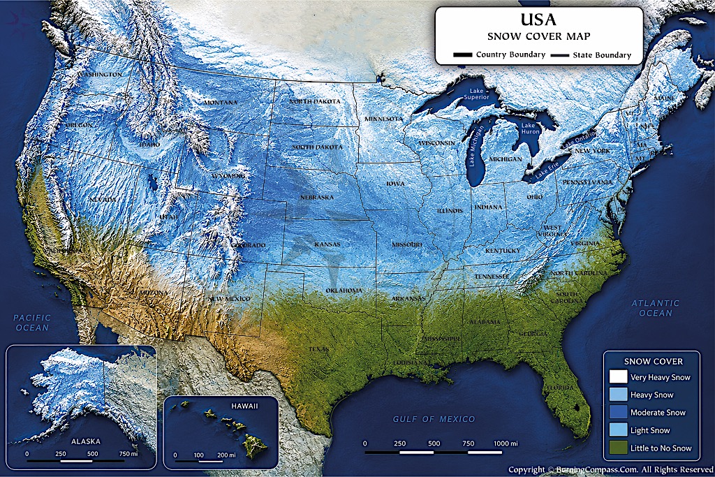
This US snow cover map displays information on where it is snowy and how much snow there is on the ground. This information is grouped into five categories: very heavy snow, heavy snow, moderate amounts of snow on ground, light amounts of snow on ground, and little to no snow on ground. Much of the northern United States has extensive amounts of snow on the ground including parts of the Rocky Mountains, northern parts of the Plains, the Great Lakes, and the Northeast. There is particularly heavy amounts of snow in the high country of the western states with amounts of snow decreasing as you travel south. There are lots of areas of very snowy terrain in Alaska. Hawaii is the complete opposite with little to no snow on the ground except at the highest of elevations. State and country boundaries as well as lakes, oceans, and terrain information are also displayed on the snow cover map of the United States.
Snow Cover in the United States
The depth, duration, and geographic extent of snow cover – a major feature of the winter climate in the United States – can vary from region to region. Factors such as latitude, elevation, temperature, storm tracks, proximity to large bodies of water, and prevailing winds determine where and for how long it snows. The northern states, as well as the high elevation states of the West, have the longest season of persistent snow cover. In contrast, the southern states have little to no snow for most of the winter, with the occasional extreme winter storm bringing brief periods of snow cover.
There are two different terms that are important to note: snowfall and snow cover. While the amount of snowfall can be very large, the duration of snow cover can be very short. In addition, the location with deep, long lasting snowpack is often the location with high mountains. Because of the elevation, new storms can bring in new snow before the old snow has a chance to melt.
Where Does the United States Get the Most Snow Cover?
The most extensive and persistent areas of snow cover in the contiguous U.S. are in the northern states and in the mountainous western states. The large winter snowpacks in the Cascade Range of the Pacific Northwest, the Sierra Nevada of California, the Rocky Mountains of the western states, and other high elevation mountain ranges are due in part to the cold temperatures at these high elevations. Falling water at these temperatures is in the form of snow.
Large areas in the northern Great Plains, Upper Midwest, Great Lakes and northern New England have seasonal snow cover. While there is snow on the ground in parts of Minnesota, Wisconsin, Michigan, North Dakota, Vermont, New Hampshire and Maine for part of the winter, the length of time that it lasts can vary greatly from year to year.
For areas at lower latitudes with high elevations, large amounts of snowfall can occur during the winter months. The low elevation areas that surround these high elevation areas can remain snow-free even though the high elevation area is covered in thick layers of snow.
The current set of U.S. Climate Normals for temperature and other variables for the period 1991–2020 were based on a large amount of data, including snowfall, for thousands of locations across the country. The Climate Normals were developed to allow for a comparison of typical winter conditions at any location. However, the amount of snow in any given year can differ greatly from typical winter conditions at that location.
Snow Cover in the Western United States
High elevation is typically associated with snow in the western states. The major mountain ranges of the western states including the Cascades in the states of Washington and Oregon, the Sierra Nevada in California, and the Rocky Mountains extending from the northern states down through Colorado and into New Mexico have the largest seasonal snowpack in the country.
Mountain snow packs act as natural reservoirs or storage facilities for water. As snow falls on the ground during the cold months of the year, it acts as a reservoir or storage facility until the warmer temperatures of spring and summer melt the snow. As the snow melts, it becomes runoff that is fed into rivers, recharges soil moisture, is captured in reservoirs, and used by various water users including communities, agriculture, and ecosystems as well as other water users downstream.
In natural water storage, such as in mountain snow, great amounts of attention are given. The streamflow in the western U.S. is comprised of 53% of melt from snowpacks. In the mountainous regions of the U.S. this value can reach up to 70%. For the Colorado River Basin as a whole, 75% of the streamflow in the Upper Colorado River Basin is comprised of the melt from snowpacks in the mountainous areas of the watershed.
Snow water equivalent (SWE) or Snow Water Equivalent is the measurement of the amount of water contained in a given volume of snow, in contrast to simply measuring the depth of the snowpack. SWE can be expressed in units of length (e.g., mm, inches) and therefore is far more useful for water supply purposes than simply the depth of the snowpack.
Individual watersheds with high snowpacks can have SWE values far in excess of these regional averages. The average maximum SWE for the Columbia–Snake region for the period of water years 2010–2020 was 169 mm/yr, while the average maximum SWE for the Pacific Northwest region for the same period of time was 117 mm/yr.
Snow Cover Around the Great Lakes and Northeast
The snowfall in parts of the Midwest and Northeast is affected by the Great Lakes. As cold air collects heat and moisture from the relatively warmer lake water, it produces intense bands of lake-effect snow downwind of the lake. These snow bands can produce large amounts of snow in a very small area, sometimes just a few miles wide.
This type of snowfall is especially common in areas of Michigan (Upper Peninsula), Ohio, Pennsylvania and in upstate New York that are located downwind of the Great Lakes. In many cases, narrow snow bands develop which can drop a lot of snow in a small area. In some cases, there can be little to no snow just a few miles away.
The Appalachian Mountains and New England receive significant amounts of winter snow. The higher elevation locations, and the northern locations, will typically keep the snow longer than the lower elevation coastal locations. Therefore, locations such as Maine, New Hampshire, and Vermont, as well as the mountainous regions of New York, can keep snow on the ground for several months during the colder or snowier years.
Snow Cover Across the Central United States
For the Great Plains and central US states, the amount of snow cover can vary greatly from north to south. States like Montana, North Dakota, South Dakota, and Nebraska will have widespread snow cover during periods of Arctic air masses and winter storms.
For states in the southern portion of the central United States such as Kansas, Oklahoma, and Texas, winter storms can bring large amounts of snow. However, the amount of time the snow will remain on the ground is typically less than farther north due to frequently changing temperatures. The snow will typically melt quickly on surfaces when temperatures are above freezing.
The depth of snow on the ground can also be affected by the strong winds in the open space of the Great Plains. These strong winds can strip exposed surfaces of the accumulated snow and move it to deep drifts in sheltered locations. Thus, the measured snow depth can vary greatly within a small area.
Snow Cover in the Southern United States
Much of the Southeast does not have long lasting snow cover for the winter due to warmer than normal winter temperatures. There is little to no snow for the season along the Gulf Coast, in Florida and in the lower lying areas of the Deep South.
However, the occasional cold spell may bring brief instances of snow to parts of Texas and down into the Carolinas.
Note that as always, elevation makes for an interesting exception. Higher elevations in the southern Appalachian Mountains (such as western North Carolina and eastern Tennessee) have a cold climate with a lot of winter time snow.
Snow Cover in Alaska and Hawaii
Alaska is home to the most extensive and persistent snow-covered landscapes found in any of the U.S. states. Due to its high latitude, very cold climate, long mountain chains, large number of glaciers, and long winters, large areas of persistent snow exist throughout the year. This includes the high mountain terrain and many of the glaciers that are covered by snow and ice throughout the summer.
Hawaii represents the exact opposite case. Even though most of the islands in Hawaii are located in a tropical or subtropical climate, with little to no snow in normal years, there are occasional instances of snowfall on the highest summits of the islands. On the Island of Hawaii, for example, it occasionally snows near the summits of Mauna Kea and Mauna Loa during certain winter weather systems in which temperatures fall below freezing.
How Snow Cover Changes Through the Seasons
For the contiguous U.S., the seasonal snow cover typically starts to increase in the fall, as temperatures begin to drop in the northern states, and at the higher elevations. By December, January, and February, the snow cover becomes much more extensive as winter conditions move southward.
As winter begins to fade, the snow that remains will move to higher elevations and generally north of where it currently exists. While low lying areas will see their snow melt out first, deep mountain snowpack can persist for months and even into summer in some cases.
Variability exists from year to year in the timing of when snow cover appears and disappears. This is often affected by large scale atmospheric and oceanic patterns that can influence winter conditions. Years with cold and stormy winter seasons can have large amounts of long lasting snow cover, while years with warm and dry winter seasons can have very little snow cover.
Satellite observations of changing snow cover can also be monitored. The U.S. National Ice Center’s Interactive Multisensor Snow and Ice Mapping System provides daily Northern Hemisphere snow-cover analyses from satellite data and in-situ observations at a variety of spatial scales including 1 km, 4 km, and 24 km. These data are available from 1997 to present.
Why Snow Cover Is Important
Snow cover is more than winter weather. It affects the nation’s hydrologic cycle, climate system, and ecosystems as well as agriculture, recreation, transportation and water supply.
The temporary water storage that falls as snow in the mountains of the West will eventually melt and become available later in the season when the weather turns to be warmer and drier during the spring and summer months.
In addition to recharging soil moisture and groundwater, the meltwater from the snow can contribute to streamflow and to storage in downstream reservoirs. The water stored in the snowpack as snow water equivalent (SWE) is a temporary form of water storage that can contribute to soil moisture, streams, and to water stored in downstream reservoirs. In most of the contiguous US, the seasonal snowpack completely melts out in the spring and summer months.
The timing of when the snowmelt occurs is important. A early start to the melt can cause the date that the water is available in the rivers and in the reservoirs to occur earlier in the season. This can affect the amount of water that is available during the dry season of the year. Monitoring of the snowpack is important for the water resources planning in the western United States.
Snow Cover and Long-Term Climate Trends
Note: The fluctuations between “snowy” years and “snow-poor” years from one year to the next are not indicators of any change in the long term. The years of varying amounts of snow are evaluated on the basis of decades of observations.
According to satellite measurements, there has been an overall decline in Northern Hemisphere snow cover for the last four decades. The biggest decrease in Northern Hemisphere spring and summer snow cover has been bigger than the increases in autumn and winter snow cover, resulting in a net decrease in Northern Hemisphere snow cover over the last four decades. However, the change in snow cover varies greatly by season and location. (National Snow and Ice Data Center)
While total precipitation may remain relatively constant, the amount of time that water is available seasonally can change depending on how long it takes for the snowpack to melt in regions that rely on the mountain snowpack for their water supply. This can happen even when the total amount of precipitation does not change.
FAQs about Snow Cover in the United States
Other US Maps
- US Map
- Detailed US Map
- Blank Map of US
- USA Karte
- Mapa de Estados Unidos
- Carte des États-Unis
- Mapa dos Estados Unidos
- USA Time Zone Map
- US National Parks Map
- US Regions Map
- US Rivers Map
- USA World Map
- USA on World Map
- US Cities Map
- US State Abbreviation Map
- US Road Map
- US Travel Map
- US Rail Map
- US Territory Map
- US Zip Code Map
- US Physical Map
- US County Map
- Blank US County Map
- US Population Map
- Richest Cities in US
- US International Airports Map
- US Flag Map
- US Map Upside Down
- US Temperature Map
- US Latitude and Longitude Map
- East Coast Map
- West Coast Map
- Western US Map
- US Interstate Map
- USA Seismic Zones Map
- US Canada Map
- US Mexico Map
- Southern US Map
- US Elevation Map
- US Map Black and White
- US Midwest Map
- US Northeast Map
- Amtrak Map
- 13 Colonies Map
- Washington DC Map
- Best Places to Visit in Summer in USA
- US on North America Map
- Southeast US Map
- US Mountain Ranges Map
- Southwest US Map
- Northwestern US Map
- US Map without Names
- US Canada Border Map
- US Area Code Map
- American Civil War Map
- US Road Trip Map
- US Volcano Map
- New England Map
- US Satellite Map
- US Desert Map
- US Map 1860
- US Map 1800
- US Map 1850
- US Lakes Map
- Where is Niagara Falls
- Where is Grand Canyon
- Where Mount Rushmore
- Where is Statue of Liberty
- Where is White House
- Where is Hoover Dam
- Where is Golden Gate Bridge
- Where is Hollywood Sign
- Where is Empire State Building
- Where is Monument Valley
- Where is Lincoln Memorial
- Where is Gateway Arch
- Where is Great Smoky Mountains
- Where is Sears Tower
- Where is Independence Hall
- Where is One World Trade Center
- US Climate Map
- Where is Rocky Mountains
- Where is Old Faithful Geyser
- US Capital
- US Map in Gujarati
- US Lightning Map
- US Snow Cover Map
- US Topographic Map
- Central US Map
- US Ethnicity Map