



About Central US Map
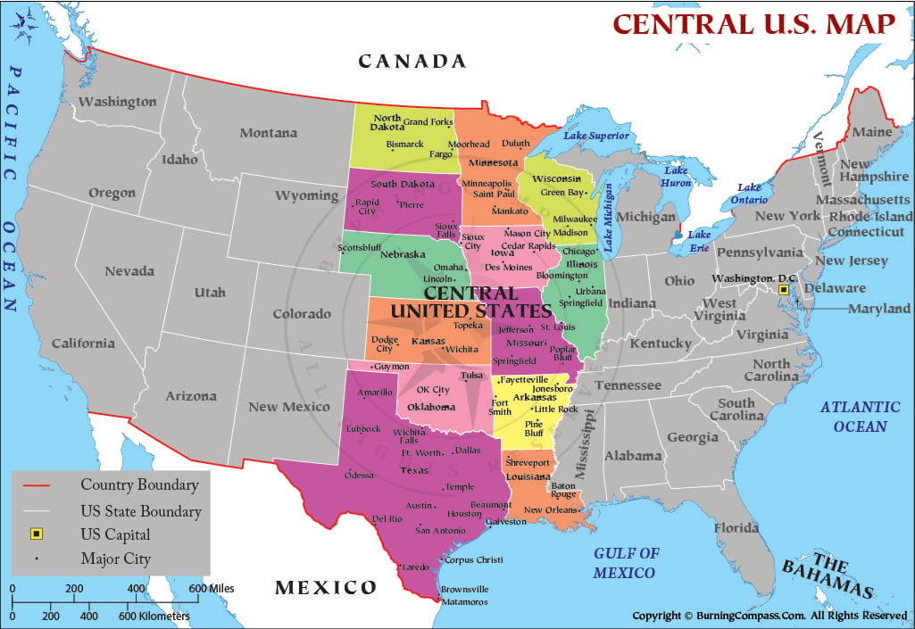
This Central United States map highlights the states in the central region of the country extending from North Dakota and Minnesota in the north to Texas and Louisiana in the south. The highlighted states are North Dakota, South Dakota, Nebraska, Kansas, Oklahoma, Texas, Minnesota, Iowa, Missouri, Arkansas, and Louisiana. The states surrounding this region are colored gray to give you a sense of their location. The map of Central United States also includes Canada and Mexico in the north and south borders. The Great Lakes, Gulf of Mexico, Pacific Ocean, and Atlantic Ocean are all labeled on the Central US map. Washington, D.C. is indicated as the U.S. capital. Major cities in the region are marked with dots, and the map includes scales to measure distances in miles and kilometers.
Central United States
Unlike the Northeast, Midwest, South, and West regions, "Central United States" or "central U.S." is not a geographic region defined by the U.S. Census Bureau. Therefore, the area known as the Central United States can be defined in terms of geographic, cultural, economic, or statistical regions. For example, the U.S. Census Bureau divides the United States into four geographic regions, which in turn are divided into nine geographic divisions. There is no single geographic region known as the Central United States.
In the map of the Central United States above, 11 states have been highlighted: North Dakota, South Dakota, Nebraska, Kansas, Oklahoma, Texas, Minnesota, Iowa, Missouri, Arkansas, and Louisiana. These 11 states comprise 7 states of the Census Bureau’s West North Central Division (Iowa, Kansas, Minnesota, Missouri, Nebraska, North Dakota, and South Dakota) plus the 4 states of the Census Bureau’s West South Central Division (Arkansas, Louisiana, Oklahoma, and Texas). Within the Census Bureau’s definitions, the 7 West North Central states are considered part of the Midwest Region, while the 4 West South Central states are considered part of the South Region.
Geography of the Central United States
The geography of the Central United States varies greatly from the Canadian border in the north to the Gulf of Mexico and Mexican border in the south. The western part of the Central United States is generally considered to be part of the Great Plains. The Great Plains are an interior region of North America that extends from Canada in the north to Mexico in the south. Prior to settlement by Europeans, much of the Great Plains was covered by grasslands extending from the Texas Panhandle northward. Trees in the region historically were found along rivers and within floodplains.
Further east, much of the Central States consist of wetter prairies, intensifying into agricultural regions, forest, and major river valleys and drainages. Much of the Great Plains region consists of several major river basins including the Missouri River system and the Arkansas River system. Throughout much of the eastern portion of the region, the major Mississippi River flows southerly through several states before entering the Gulf of Mexico in Louisiana.
This region extends a great distance from north to south, and is characterized by vast differences in terrain and climate. Much of North Dakota and Minnesota is marked by long, cold winters, while in the southern parts of Texas and Louisiana the winters are much milder than in the north and the growing season is longer. The region includes large areas of open plains and prairie as well as river valleys, wetlands, forests and a long stretch of Gulf of Mexico coast.
States in the Central United States
The northern central states are North Dakota and South Dakota and the states of Nebraska and Minnesota and the states of Iowa. The middle section consists of the states of Kansas and Missouri and Oklahoma. The southernmost portion of the Central States consists of the states of Texas and the states of Arkansas and Louisiana.
Note that the area we have called the Central United States above is different from the Census Bureau’s definition of the Midwest Region. The twelve states of the Census Bureau’s Midwest Region are Illinois, Indiana, Iowa, Kansas, Michigan, Minnesota, Missouri, Nebraska, North Dakota, Ohio, South Dakota, and Wisconsin. The four southern states of Arkansas, Louisiana, Oklahoma, and Texas are all part of the Census Bureau’s South Region. This is why some maps may label the same area as the “Midwest” while others use the term “Central States” or “Central United States.”
Major Cities of the Central United States
The Central United States is home to numerous metropolitan centers and smaller regional cities, such as Minneapolis and Saint Paul, Minnesota; Omaha and Lincoln, Nebraska; Des Moines and Cedar Rapids, Iowa; and Wichita, Kansas City and St. Louis, Kansas–Missouri. Major cities in Oklahoma include Oklahoma City and Tulsa.
Moving to the southern portion of the region, the major metropolitan areas of Texas are Dallas–Fort Worth, Houston, Austin and San Antonio along with El Paso, Corpus Christi and Lubbock. Little Rock is the major city of Arkansas with Fort Smith being another important urban center. In Louisiana, New Orleans, Baton Rouge and Shreveport serve as important urban and business centers for the region.
Great Plains and Prairies
The Great Plains are a large area of terrain that spans from Mexico to Canada. It is one of the most well-known geographical features of the United States and is generally considered to be located in the central part of the country. This region is often considered to be generally flat but actually contains a great variety of different landscapes including grasslands, river valleys, badlands, high plateaus, deep canyons and of course millions of acres of cultivated farmland.
Agricultural development, as well as other human activities, have replaced large portions of the natural prairie with farms, ranches, cities, and roads. However, numerous areas of native grassland remain and are valuable for providing wildlife habitat and natural beauty to the American interior. These areas of native grassland occur in the wetter eastern portions of the grasslands and decline in quality as one moves west across the plains.
Many of the natural prairies have been converted to farms, ranches, cities, roads, and other uses, but there are still many grasslands left throughout the country. These remain as valuable wildlife habitat and help to define the natural heritage of the interior of the United States.
Rivers and Water Resources
The rivers of the Central United States are one of the most prominent geographical features of the area. The Mississippi River and its numerous tributaries drain much of the interior of the United States while the Missouri River serves as a major waterway through the northern and central parts of the region’s plains. Additional major rivers include the Arkansas, Red, Platte and Rio Grande, as well as their respective tributaries.
Rivers are important features that defined many early communities and currently support agricultural production, municipal supply, industrial activities, and various wildlife habitats, recreation and transportation. The Missouri basin is the largest major river basin in the Great Plains, covering over 529,000 square miles and is monitored by NOAA.
The water availability in the drier western regions of the central plains is important for agricultural production by using irrigation where necessary. In addition, groundwater is an important source of water for agricultural production, especially for irrigation from the Ogallala Aquifer that underlies parts of the Great Plains.
Climate of the Central United States
Central United States – a region so big that no single climate dominates. Conditions change from north to south and from wet east to dry west.
Northern states experience extreme cold and snow in the winter, while the southern states experience hot summers and milder winters. Moisture is also not equally distributed throughout the Central United States. According to NOAA, unirrigated summer crop production dominates in the eastern Great Plains while parts of the western plains depend heavily on irrigation for agricultural production.
In addition to usual weather conditions, the Central United States is also subject to a variety of severe weather events, such as thunderstorms with hail and strong winds, droughts and flooding, winter storms and extreme heat. The Gulf Coast of Texas and Louisiana also must prepare for the possibility of tropical storms and hurricanes.
Agriculture and the Central U.S. Economy
Agriculture is well known to be a significant portion of the Central United States’ economy. The extensive plains of the region provide a backdrop for a wide variety of agricultural production, provided by some of the world’s most productive soils, various climatic types, and an extensive network of irrigation. Agricultural commodities such as corn, soybeans, wheat, cotton, and alfalfa are produced in large quantities, and many livestock operations, including cattle, hogs, dairy, and others also call the region home. According to NOAA, the type of crop production taking place in the Great Plains can vary greatly from location to location due in part to differences in precipitation, temperature, and use of irrigation.
Beyond the farms of Texas, Oklahoma, and Kansas, the energy industry is huge in Texas and Oklahoma, and manufacturing, food processing, and related activities like transportation and logistics, finance, IT, health care and professional services create the economies of the region’s metropolitan areas. The region is also a critical thoroughfare for the movement of agricultural commodities and of manufactured goods and of energy as well as other commodities into, out of and within the U.S.
Transportation and Geographic Importance
Because many of these states are landlocked and centered in the interior of the country, they are served by key transportation routes that link the Gulf of Mexico ports with agricultural production, manufacturing, and large population centers across the country.
Another crucial transportation route is the Mississippi River system which in the South enables transportation to the Gulf of Mexico and connect inland production to international maritime trade. Many airports within the region’s major cities such as Dallas–Fort Worth, Houston, Minneapolis–Saint Paul, and others throughout the region serve not only the region but also the country and world.
Understanding the Meaning of “Central United States”
The term Central United States does not refer to a U.S. Census Bureau defined region, but rather is a geographic concept that can be portrayed on a map using various collections of states. These might include all of the states of the Midwest plus some of the neighboring states of the West North Central and South East regions of the U.S. Census Bureau defined divisions. Other maps might use a variety of different collections of states. This document uses the term to refer to 11 specific states of the U.S. (North Dakota, Minnesota, Nebraska, Kansas, Oklahoma, Colorado, New Mexico, Texas, and the 3 Gulf States of Louisiana, Arkansas, and Mississippi).
In constructing the map above for the term Central United States, we are strictly defining it to include the 11 states outlined in the map: ND & MN and the states south to TX & LA. By clearly stating this definition for this term as opposed to the term the Midwest, we attempt to include all relevant cities, landscapes, rivers, transportation, and economic activity within the heart of the country for in-depth examination.
FAQs about Central United States
Other US Maps
- US Map
- Detailed US Map
- Blank Map of US
- USA Karte
- Mapa de Estados Unidos
- Carte des États-Unis
- Mapa dos Estados Unidos
- USA Time Zone Map
- US National Parks Map
- US Regions Map
- US Rivers Map
- USA World Map
- USA on World Map
- US Cities Map
- US State Abbreviation Map
- US Road Map
- US Travel Map
- US Rail Map
- US Territory Map
- US Zip Code Map
- US Physical Map
- US County Map
- Blank US County Map
- US Population Map
- Richest Cities in US
- US International Airports Map
- US Flag Map
- US Map Upside Down
- US Temperature Map
- US Latitude and Longitude Map
- East Coast Map
- West Coast Map
- Western US Map
- US Interstate Map
- USA Seismic Zones Map
- US Canada Map
- US Mexico Map
- Southern US Map
- US Elevation Map
- US Map Black and White
- US Midwest Map
- US Northeast Map
- Amtrak Map
- 13 Colonies Map
- Washington DC Map
- Best Places to Visit in Summer in USA
- US on North America Map
- Southeast US Map
- US Mountain Ranges Map
- Southwest US Map
- Northwestern US Map
- US Map without Names
- US Canada Border Map
- US Area Code Map
- American Civil War Map
- US Road Trip Map
- US Volcano Map
- New England Map
- US Satellite Map
- US Desert Map
- US Map 1860
- US Map 1800
- US Map 1850
- US Lakes Map
- Where is Niagara Falls
- Where is Grand Canyon
- Where Mount Rushmore
- Where is Statue of Liberty
- Where is White House
- Where is Hoover Dam
- Where is Golden Gate Bridge
- Where is Hollywood Sign
- Where is Empire State Building
- Where is Monument Valley
- Where is Lincoln Memorial
- Where is Gateway Arch
- Where is Great Smoky Mountains
- Where is Sears Tower
- Where is Independence Hall
- Where is One World Trade Center
- US Climate Map
- Where is Rocky Mountains
- Where is Old Faithful Geyser
- US Capital
- US Map in Gujarati
- US Lightning Map
- US Snow Cover Map
- US Topographic Map
- Central US Map